China 'likely' sent drones to map out Philippines' underwater terrain — Navy
MANILA, Philippines — Two underwater drones that Filipino fishermen discovered within Philippine waters last year were likely deployed by the Chinese government for military purposes, a Philippine Navy spokesperson said on Tuesday, April 15.
Rear Adm. Roy Vincent Trinidad, Navy spokesperson for the West Philippine Sea, shared the AFP's findings from a forensic analysis of five recovered drones on Tuesday and said there is a "a 55 to 80 percent likelihood" that two of these drones were sent by China.
"Why 55 to 80 percent? It's because of the components inside. Not all of them have markings that they were made in China. Others are available commercially off the shelf," Trinidad said at a press conference.
"They have the capability to receive, to process, to store, and to transmit data through satellite communications to a station on land, to a mothership, or to other drones. We are not categorically stating where they came from, but there is a likelihood, a 55 to 80 percent likelihood per the report," the Navy spokesperson added.
The AFP recovered five underwater drones (also called gliders) in various parts of the country from 2022 to 2024 and has stopped short of accusing a specific country of deploying these pending an official investigation. Tuesday's announcement marks the first time the AFP presented forensic evidence linking these surveillance devices directly to the Chinese government.
The military's findings raise significant "security implications" for the Philippines, as Trinidad warned that the data collected by these drones could be used for mapping the Philippines' underwater terrain — an "essential step to undersea warfare" by potential adversaries.
Drones found in 'strategic' areas
The five underwater drones were scooped out of waters in the following locations: drone #1 in Ilocos Norte (2022), drone #2 in Zambales (2022), drone #3 in Calayan, Cagayan (2024), drone #4 in Initao, Misamis Oriental (October 2024) and drone #5 in San Pascual, Masbate (December 2024).
Trinidad noted that these locations are strategically significant, particularly because they are near critical maritime passageways.
"They are important ... in the defense and security not only of the country but for international maritime navigation," Trinidad said. "The first three were found up north, Pasukin, Ilocos Norte, Calayan Island, Cagayan, the coastal area of Zambales. These are just a little bit south of Balintang Channel, which is an international sea lane."
The other drones were similarly found near key maritime choke points. "The fourth one was found in the coastal area of Misamis Oriental, which is just west of Surigao Strait, another choke point. And the fifth was found in Masbate, which is also just west of San Bernardino Strait, another critical choke point," Trinidad said.
Of the five recovered devices, most were intact when found.
"Of the five in our possession right now, the second was damaged. We received the major component of it on the wave glider. The four others were intact," Trinidad reported.
Based on the forensic investigation completed so far, Trinidad said the drones are believed to be capable of receiving, storing and transmitting data through satellite communications to a station on land, a mothership, or to other drones.
Forensic evidence
At Tuesday's press conference, Trinidad detailed the AFP's forensic investigation process for the drones, which included two levels of examination.
The AFP has so far conducted what they called "Level 1 Exploitation" on all five drones, examining physical characteristics such as dimensions, weight, color, and external markings, while "Level 2 Exploitation," involving internal examination, has been completed for the 1st, 3rd, and 4th drones.
Trinidad clarified that not all five drones have markings that they were made in China. "Others are available commercially off the shelf," he said.
It is drones #3 and #4 that the AFP believes have a "55 to 80 percent" likelihood of being of Chinese origin.
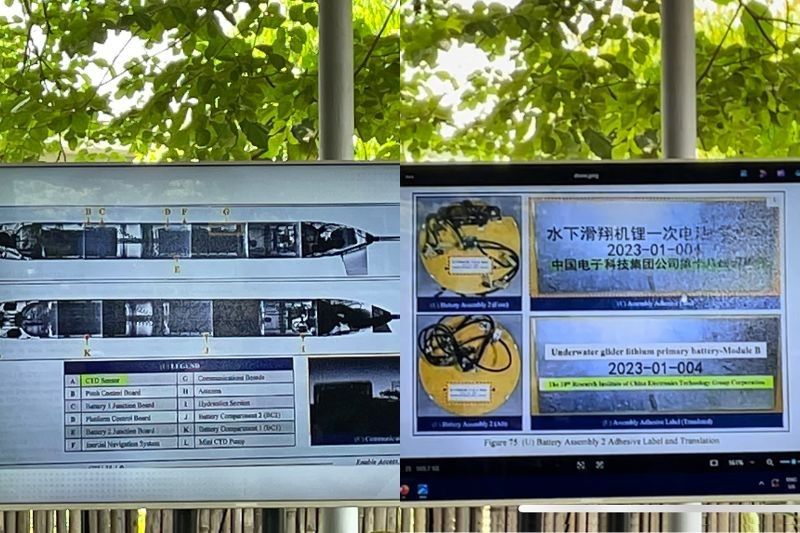
The third drone, recovered in August 2024 in Cagayan, bore markers that indicated it was of Chinese origin. Trinidad described it as "the most intact one" and revealed it had a CTD (conductivity, temperature, and depth) sensor with external Chinese markings.
A CTD sensor measures water salinity, temperature gradients, and precise depth measurements.
More significantly, some of drone #3's integrated chips were "sanitized or were defaced," which Trinidad said was likely done "to prevent reverse engineering or to hide the source."
"There was an Iridium transceiver with serial number HWA-Create. HWA-Create is a company that focuses on defense, civil, government and industrial solutions, the headquarters of which is in Beijing," Trinidad said.
The military also found a "China Telecom SIM card" within the device.
Trinidad noted that "based on the technical study of the SIM card, the last contact that it had was in mainland China."
The fourth drone, recovered in October 2024 in Misamis Oriental, also contained evidence linking it to Chinese military technology.
"The battery assembly had markings, 18th Research Institute of China Electronics Technology Group, the CETG Corporation or the China Electronics Technology Group Corporation," Trinidad said.
CETG is a state-owned military electronics manufacturer in China.
"The CETG corporation is also responsible for the BOIN, Blue Ocean Information Network, which is being used by the Chinese Communist Party in the South China Sea to study the underwater terrain," Trinidad said.
Military applications
Trinidad said that while these drones collect data that has legitimate scientific and commercial uses, the same information has critical military applications, particularly for "underwater warfare."
"The information gathered focuses on bathymetric data. It also collects information on sound propagation underwater. All of this information have uses commercially for scientific research, for academic purposes. They have also dual use for military use," Trinidad said.
"It's very clear that these are used for mapping out the underwater terrain, collecting information, like what I mentioned, bathymetric data. All of these are used across different fields to include underwater warfare," the Navy spokesperson added.
Trinidad said the underwater data gathering could threaten the Philippines' national security. "Underwater warfare is the conduct of warfare underwater. Before you conduct any activity, you have to know the terrain, whether on the surface, in air, or below the surface. Conducting information gathering of the underwater terrain is an essential step to undersea warfare," he said.
According to the Navy spokesperson, these drones collect precisely the specialized information needed for underwater military operations. "You need to know salinity and its effect on sound. You need to know temperature's effect on sound. You need to know how sound propagates underwater, depending on the depth, temperature, and other factors," he said.
"Any potential adversary who would like to harm our country would need information not only on land and air but, more importantly since we are an archipelago, underwater information. These drones give them that information," he said.
Jonathan Malaya, spokesperson of the National Task Force for the West Philippine Sea (NTF-WPS), said the forensic investigation points to "conclusive" evidence of China sending drones to map the Philippines' underwater terrain.
"The forensic examination on the submersible drones have allowed us to conclusively determine that they are of Chinese origin. They are also in all likelihood deployed by China to map the PH's underwater terrain," Malaya said.
"This is alarming because of its implications to national security. This only shows that we need to be more vigilant and we need to undertake more maritime patrols in more parts of the country to stop these types of activities," he added.
Countermeasures
Trinidad acknowledged that "any modern armed force in the world will have a big capability gap in searching for this type of equipment" since they operate beneath the surface and are relatively small.
The Philippines received help from "like-minded countries" in conducting a forensic investigation of the drones, though the Navy spokesperson declined to name which countries extended assistance.
To detect possible additional underwater drones in Philippine waters, the AFP is relying on Filipino fishermen as part of what Trinidad called a "whole of government approach, whole of nation approach."
He specifically thanked fishermen who had previously recovered the five drones in the Philippines' territorial waters.
"Whenever you see a drone like this, inform the authorities. Whether Philippine Navy, Philippine Coast Guard, Philippine National Police, or whoever is close to you, secure it, don't touch it, and inform," Trinidad said in a message to Filipino fishers.


- Latest
- Trending